


Les Crêtes : Fiss - Serfaus

CapTom
User
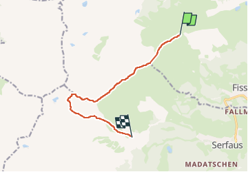

Length
9.3 km

Max alt
2794 m

Uphill gradient
506 m
Km-Effort
17.6 km

Min alt
1974 m

Downhill gradient
967 m
Boucle
No
Creation date :
2024-09-02 08:43:01.0
Updated on :
2024-09-02 14:09:57.193
3h09
Difficulty : Difficult

FREE GPS app for hiking
 SityTrail
IGN / Geographical institutes
SityTrail Plus
The world is yours!
About
Trail Walking of 9.3 km to be discovered at Tyrol, Bezirk Landeck, Gemeinde Fiss. This trail is proposed by CapTom.
Positioning
Country:
Austria
Region :
Tyrol
Department/Province :
Bezirk Landeck
Municipality :
Gemeinde Fiss
Location:
Unknown
Start:(Dec)
Start:(UTM)
620458 ; 5214718 (32T) N.
Comments